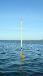
1. The pylon is now ready for electronics installation. There
remains a very slight lean to the southeast which Hector
and myself can adjust on the next trip - Jan. 9. The
NOAA emblems and web address side is pointing
due magnetic North. There is no twisting observed
on the baseplate tie downs. The light is operational and
can be seen from the town on the horizon at night.
2. Additional concrete was added to the base. We would
like to build it up a bit more on the next trip.
3. A great amount of biofouling - algae and barnacles- was
observed on the chains and stainless shackles for the upper
1/3 of the water column. This occurred in the 54 days since
deployment. We removed most of this and also cleaned each
of the legs.
4. All stored equipment, concrete, and red box had not been
tampered and our remaining hand truck was with the equipment.
--Jules Craynock
This site is for recording maintenance records of the La Parguera Marine Reserve NOAA ICON/CREWS station for data management purposes. Please update this blog whenever new operations are performed in the field, so that NOAA/AOML can coordinate data management efforts with the La Parguera ICON/CREWS station field efforts.
Tuesday, December 13, 2005
Thursday, October 20, 2005
Pylon Installed
 The new ICON/CREWS station was installed to the bottom plate in La Parguera Marine Reserve, Puerto Rico, at 9:22am, October 18th. The USCG was informed that same day. After two intense, full days of underwater work, the station was completed near sundown on October 19th. The NOAA Working Divers completing this work were Jules Craynock (UDS), Scott Stolz, Jeff Judas and Hector Casanova. Jeff Absten and Jim Hendee assisted with the installation and organization of future maintenance and research aspects with the University of Puerto Rico Department of Marine Science staff on Magueyes Island. Dr. Roy Armstrong of UPR/DMS is the local contact.
 At this time, the only operational part of the station is the navigational light (white, half-second flash every four seconds, visible for 3.2 nm). This is apparently the only navigational light between Cabo Roja and Ponce, and will serve as a good entrance channel marker to the Reserve and general embayment area. The instruments and electrical infrastructure are scheduled to be installed during the week of December 5th, 2005. Final rigging adjustments will also be attended to at that time. The sensors will include those for measuring wind speeds and gusts, barometric pressure, relative humidity, precipitation, photosynthetically available radiation (PAR, above and below water), ultraviolet radiation (UV 305, 330, 380nm, above and below water), state of tide, sea temperature, salinity, and pulse amplitude modulating (PAM) fluorometry on up to four species of coral.
Cheers, Jim Hendee
Thursday, October 06, 2005
Stick is on the way!
The pylon was shipped from AOML on October 5, 2005, to La Parguera for installation during the week of October 17, 2005. Electronics installation will occur at a later date, hopefully during the week of December 5, 2005.
Jim
Jim
Saturday, August 20, 2005
More on LPPR1
Base mounting installation for LPPR1 was conducted in the period Aug.16-19, 2005. Eight peripheral Manta mountings were deployed in the surrounding sand utilizing a hydraulic jack hammer and load locker assembly. The central stainless baseplate with ball was installed as part of an integral concrete base support, constructed u/w on existing rock substrate with poured concrete.
Jules Craynock
Thursday, June 09, 2005
Puerto Rico CREWS Site
The proposed site for the first CREWS station in Puerto Rico is at Media Luna Reef, latitude 17o 52.326'N, longitude 67 o 03.128'W, in 20' of water, within the La Parguera Marine Reserve.
Subscribe to:
Comments (Atom)